Posted on May 25, 2022 in Help and UAV LiDAR
In a series of articles, we’ll answer the frequently asked questions about UAV LiDAR including how it works, the alternatives, the benefits and the best applications for the technique, what is important to know when purchasing a UAV LiDAR system and what to consider when using a UAV LiDAR system.
In this first article we’ll give a high-level overview of UAV LiDAR technology. We’ll discuss what UAV LiDAR consists of, how it compares to other forms of LiDAR acquisition types, describe its benefits and best use cases.
What is LiDAR?
Light Detection and Ranging (LiDAR) is a remote sensing technology used for the acquisition of information about objects or phenomenon without making physical contact with any of them. LiDAR fulfils this objective using lasers, which are devices that emit light waves to measure the distance to a surface or sense objects. The energy emitted from a LiDAR system is called ‘pulse’, while the light reflected from the ground or object is called ‘return’. Using the speed of light and measuring the time to return to its source, it is possible to accurately measure the distance from the sensor to an object or ground in three dimensions.
A collection of measurements in the form of LiDAR points is called a point cloud and is used to create a 3D representation of the surrounding area or object. In addition to performing accurate distance measurements, a point cloud allows for object extraction and classification. LiDAR technology is used for many different applications, ranging from topographical mapping to mapping indoor spaces for cultural heritage projects, construction and architecture.
UAV LiDAR: an alternative for both terrestrial and airborne LiDAR
LiDAR data is acquired using a variety of platforms such as Unmanned Aerial Vehicles (UAVs), airplanes, cars, backpacks or by using static terrestrial laser scanners. A UAV or drone is an aircraft without a human pilot, crew, or passengers on board.
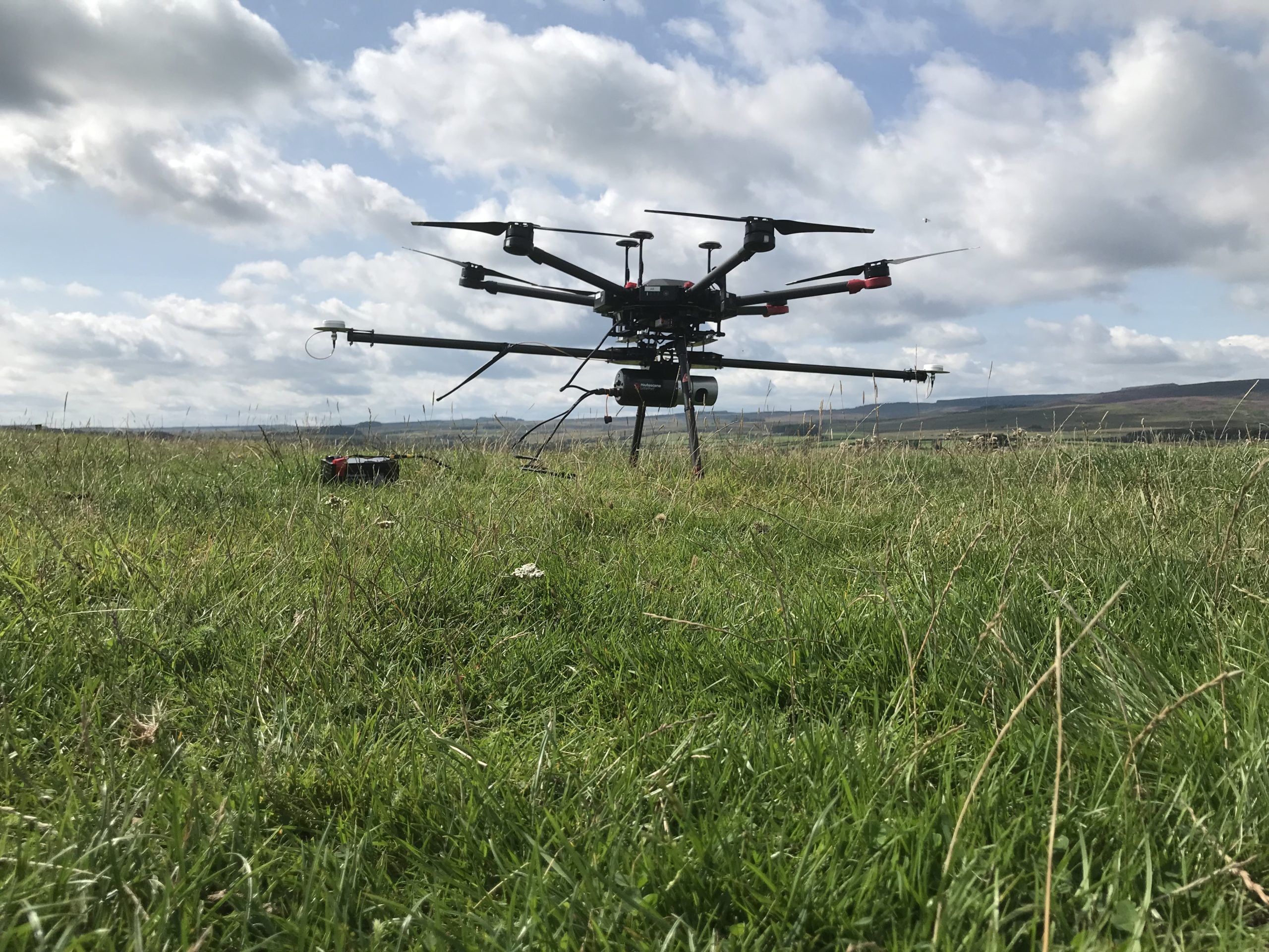
When a UAV carries a LiDAR system and is used to capture data about the surroundings, the term UAV LiDAR is used. A UAV LiDAR system typically includes a number of sensors including a LiDAR sensor, GNSS (Global Navigation Satellite System) receivers to position the pulse and an IMU (Inertial Measurement Unit) to determine the orientation and speed of the LiDAR payload.
UAV LiDAR can be used as an alternative to other LiDAR types and platforms for producing precise and accurate 3D maps and models.
UAV LiDAR as an alternative to airborne LiDAR
Airborne LiDAR uses a manned aircraft or helicopter to capture a 3D point cloud of the earth’s surface, to be rendered as a DTM (Digital Terrain Model) or DSM (Digital Surface Model). Normally, airborne LiDAR is used for wide-area topographical mapping, where high accuracy and high resolution point cloud data over thousands of square kilometres of terrain is captured in a single project.
In contrast, drone LiDAR system users have taken full advantage of the technology to map smaller sites however over the last 2-3 years there has been an increasing expectation to extend these benefits to larger survey areas. Additionally, longer endurance drones are now available which will widen the type of applications UAV LiDAR can be used for.
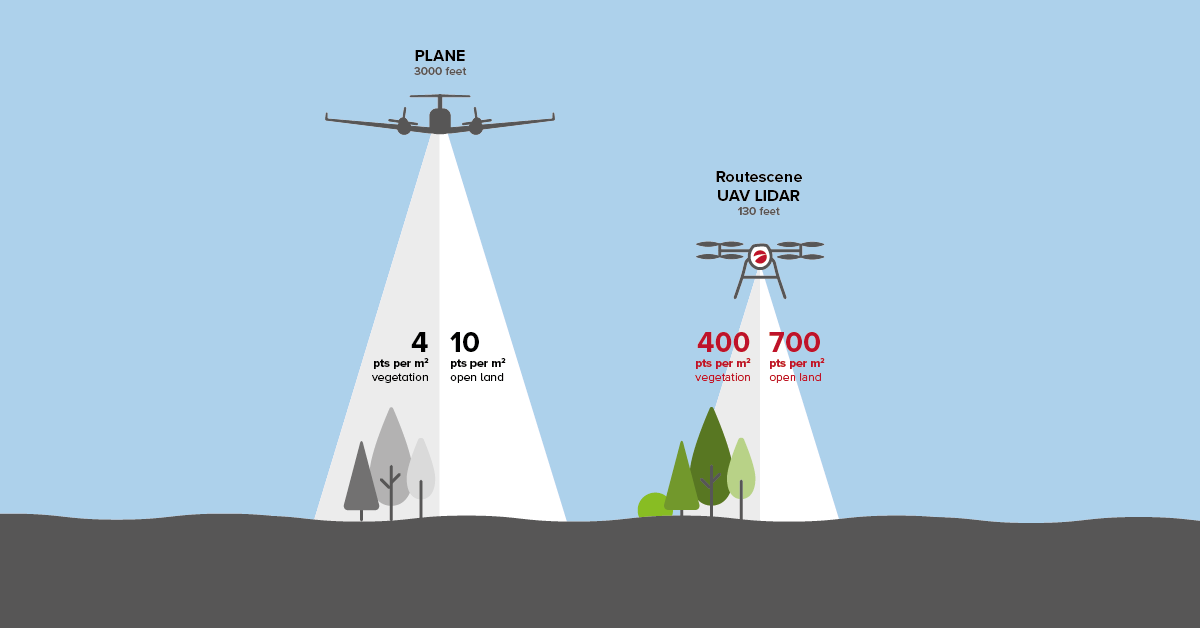
When comparing UAV and airborne LiDAR, the former is limited to a 400 foot altitude-ceiling, which is based on the minimum safety altitude of manned aircraft. While drones are legally not able to fly as high or as fast as manned aircrafts, these features actually make them more suitable for certain use cases than airborne LiDAR.
UAV LiDAR as an alternative to terrestrial LiDAR
Static terrestrial LiDAR or laser scanning takes place on the surface of the earth, sensors usually being mounted on a tripod.
This technique is used for mapping buildings, terrestrial features and trees at ground level. Stationary terrestrial scanning is a very common survey method. A terrestrial laser scanner is a contact-free measuring device, typically a single rotational laser sensor which can scan a full 360 degree field of view, to collect dense point clouds of objects.
These are matched with digital images taken of the scanned area from the scanner’s location to create realistic 3D models.
With the emergence of LiDAR, drones and GNSS, what once required teams of people on months-long surveying and mapping projects can now be done more efficiently, in less time and more cost effectively.
UAV LiDAR best use cases
Although used for many different applications, we present two best cases for UAV LiDAR: when you need to penetrate through vegetation to achieve a DTM rather than a DSM, or to overcome difficult terrain or hazardous locations, such as landslides.
Use case 1: Creating a DTM with UAV LiDAR
Because laser pulses emitted from a LiDAR system reflect from objects both on and above the ground surface, LiDAR is a very useful technology for penetrating vegetation from the air to see the ground below.
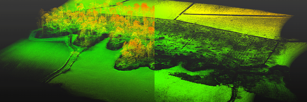
As stated above, airborne and UAV LiDAR is used to create accurate 3D models in the form of DTMs and DSMs. The difference between the two is subtle: a DSM is a 3D representation of terrain and all the objects within that space; whilst in a DTM all the objects (for example trees, vegetation and buildings) have been removed so that only the ground surface remains.
DTMs are particularly useful for a myriad of forestry management applications, as UAV LiDAR visualizes both the forest and the ground. The point cloud data is used to create models of the canopy structure, providing specific information such as tree volumes and tree height.
Here’s a case study where a DTM was used to inform operational forestry management.
Use case 2: Overcoming difficult terrain or hazardous locations with UAV LiDAR
UAV LiDAR can help mapping companies to overcome difficult terrain or hazardous locations. Using a drone instead of personnel to map hazardous or difficult areas increases safety, speed, efficiency and data quality. Take for example open-pit mines, which are dangerous places to work because of the many cliffs and steep embankments that may collapse. Using UAV LiDAR can help you identify both dangerous and safe areas at a mine site.
Surveying steep slopes is challenging for multiple reasons, one of them being inaccessibility for ground crew. Applications such as dam and water conveyance, infrastructure surveying, landslide mapping, pipeline inspection and surveying archaeological sites have all benefited from UAV LiDAR, which proved a better alternative to hazardous ground surveying or airborne LiDAR mapping.
Here’s an example where it helped protect properties and lives from landslides in Ystalyfera, South Wales, UK.
Advantages of using UAV LiDAR
UAV LiDAR has multiple advantages compared to both airborne and terrestrial LiDAR, including enhanced safety, cost effectiveness, speed of data collection and higher data quality.
UAV LiDAR increases personnel safety
Considering the health and safety aspects and striving to achieve safer working conditions is of high importance regardless of the industry.
UAV LiDAR offers great advantages in hazardous environments where you do not wish to send people and to survey areas which are difficult or impossible to undertake by other means, including open cast mines, landslides or areas containing land mines. By letting the drone fly over the area of interest, you do not have to access the area yourself and put your safety at risk. This also frees you from having the stress to protect yourself and your equipment while being in a risky situation, or rushing the work in order to escape the hazardous environment, which might lead to bad measurements or low quality data.
Drone LiDAR is more cost effective than airborne LiDAR
The acquisition of UAV LiDAR data can be done in a timely, accurate and safe way, and at a cost much lower than that of surveys using manned aircraft.
While airborne LiDAR is a great fit for wide-area mapping of large expanses of land, UAV LiDAR is a more cost effective and versatile choice for smaller areas, requiring less time, personnel and a smaller system to quickly produce high quality data of your area of interest.
UAV LiDAR makes for fast data collection
Traditional surveys can take days or weeks to capture data. Imagine using a single terrestrial laser scanner that needs to be moved frequently to completely map a large area. This is not a scalable approach that allows you to finish projects quickly or makes you more productive over time.
With drone LiDAR you will spend less time gathering data. A survey can be completed within hours and processed within the same day, giving you results rapidly enabling faster decision making. Brisk turnaround times to capture data and provide high resolution outputs means UAV LiDAR now offers a cost-effective, viable alternative for terrestrial mapping and surveying projects.
Drone LiDAR produces high resolution data
UAV LiDAR systems can produce high accuracy and high resolution point data. Both accuracy and resolution are an outcome of the system’s capabilities, the type of survey that is being conducted and flying height:
Data resolution refers to the level of detail captured by the LiDAR system and is expressed as the number of points per square meter. For UAV LiDAR the number of points per square meter is high, because you fly lower and slower, compared to other aerial options such as helicopter or plane. In summary, UAV LiDAR has a very high data resolution compared to airborne:
Surveying a site with very dense vegetation requires you to fly low and slow, but depending on the quality of the LiDAR sensor within your system, you still may not achieve the required level of resolution.
Data accuracy can be defined as how close a measurement is to its real value. Data accuracy depends on the LiDAR system and the quality of the LiDAR and INS sensors inside it. Additionally, the nature of a survey will directly affect data accuracy: surveying very tall trees for example means you have to fly much higher to avoid the tallest tree, which will generate less accurate data than flying low over a sparsely vegetated site or a site with no vegetation. Data accuracy is explained in more detail in the following article.
Summary
In this article, we’ve explained what UAV LiDAR is, how UAV LiDAR compares to other forms of LiDAR acquisition types, its benefits and best use cases.
LiDAR is a remote sensing technology that is used for many different applications. When a UAV carries a LiDAR system payload and is used to capture data about the surrounding area, the term UAV LiDAR is used.
UAV LiDAR is ideal when you need to penetrate through vegetation to achieve a DTM rather than a DSM, or to overcome difficult terrain or hazardous locations, such as landslides. UAV LiDAR systems can produce high accuracy and high resolution point data. Data resolution and accuracy are impacted by both the system capabilities, the flying height achieved and the type of survey that is being conducted.
You’d like to speak with us? The Routescene team is here to help – to discuss your requirements or to give advice and customer support.