LiDAR mapping landslides in Ystalyfera, South Wales, UK
UAV (Unmanned Aerial Vehicle) LiDAR offers unparalleled capability where accurate mapping is essential but difficult to achieve. Examples include hard to reach, hazardous environments where access is dangerous, areas where there is dense vegetation or sites with inaccessible steep slopes. Landslide locations characteristically pose multiple problems and the project in Ystalyfera, Wales presented all of these challenges on a single site.
Undertaking a LiDAR survey from the air using a drone ensured the survey team were not exposed to any danger on the unsafe ground and could survey the inaccessible steep areas safely. The vegetation penetration capabilities of the Routescene RS4 UAV LiDAR System enabled the team to produce high resolution Digital Terrain Models (DTMs) to analyze the area in detail. The team returned to the site at frequent intervals over time to repeat the survey. By comparing and contrasting the series of results they were able to identify the rate and scale of ground movement across the landslide area.
A community in crisis with a history of landslides
Ystalyfera is a small town in the Swansea Valley, South Wales, UK, with a population of around 3,000 people. Its’ geology and industrial past has made it prone to landslides for over 100 years. Since 1897 there have been over 45 incidents. The landslide system is very active and further instability is likely, possibly on a frequent basis.
Thousands of tonnes of rock, soil and trees slipped down the steep hillside in 2012. Movement in 2017 forced residents to be moved out of their terraced homes for their own safety. In 2019 the local primary school was closed for safety reasons when a geological survey was carried out.
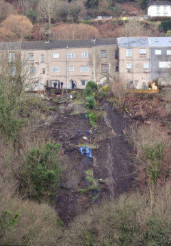
Ystalyfera properties in danger (Image credit Gayle Marsh)
Specialist team created 3D Digital Terrain Models
In 2017 Routescene customer Flythru, collaborating with Geoterra, were employed by Neath Port Talbot County Borough Council and Earth Science Partnership. Their brief was to create 3D DTMs that would assist in monitoring any landslide movement on the hillside. They performed a LiDAR survey of the village to establish and monitor land movements. This process continued in 2018.
The advantages of LiDAR mapping landslides surveys
The landslide area to be surveyed in Ystalyfera was covered with dense vegetation. This was the critical reason for choosing UAV LiDAR technology over other survey techniques. Unlike photogrammetry which captures an image of the vegetation surface only, LiDAR can penetrate through the vegetation canopy to reach the layers below and the ground. The Routescene RS4 UAV LiDAR System provides supreme performance for vegetation penetration. With a scan rate of up to 1.4 million points per second from 32 different lasers, it means many of the lasers hit the ground. Even through dense vegetation up to 400 points per m2 can readily be achieved.
Clear visual results
Once the LiDAR point cloud was collected the data was post processed using LidarViewer Pro, Routescene’s specialist software. All the trees and vegetation were removed virtually from the dataset to produce a DTM.
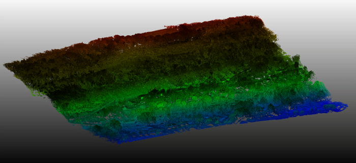
Raw point cloud showing the extensive vegetation coverage across the landslide site
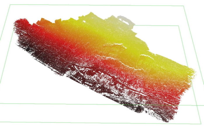
LiDAR derived Digital Terrain Model after the vegetation was virtually removed
Due to the sensitivity of the project, it was important to deliver results that could be clearly presented and interpreted by residents and the local authority. To enable this the team at Flythru overlaid the LiDAR DTMs with aerial images captured across the survey area. All the data was tied into ground control points surveyed in by the Geoterra ground crew. This enabled consistent comparisons to be undertaken over time which could be used to highlight the location and scale of any ground movements.
In conclusion, the final results enabled the local authority to evaluate options and make decisions about homes and people’s safety. These findings were presented with a risk map of the area to concerned residents at a local meeting.
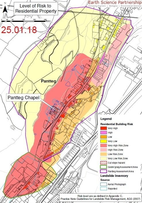
Risk map of the area
Video of the final survey results shown to homeowners:
“The UAV LiDAR System proved to be very useful for this project due to its ability to penetrate the tree and vegetation cover on the hillside. We are immensely proud to be involved with this project, which ultimately could save lives.”
Michael May from FlyThru, UK
Coverage of the landslides in Ystalyfera in the press: