Posted on January 15, 2022 in UAV LiDAR
As an early entrant in the UAV / drone LiDAR market, Routescene has been developing systems since 2013. We have observed a huge change in the market during that time and here are our predictions for 2022:
1. Lower cost to entry
Since UAV LiDAR systems first became commercially available in 2013-14 one of the most significant barriers to entry for organizations and service providers wishing to invest in this new technology has been the cost. Over the last 1-2 years, we have witnessed a steady decrease in system cost accompanied with increased choice. A wider range of systems from high specification survey-grade options to lower performance mapping-grade units is now available.
The reduction in system costs has been enabled as a direct result of component parts reducing in price; in particular the major component, the LiDAR sensors, which have reduced significantly in price. Add to this increased competition worldwide and increased demand, enabling manufacturers to enjoy economies of scale in production, and the typical factors which drive down cost have all come into play.
2. Increased demand for drone LiDAR
UAV LiDAR has carved out its niche allowing users to survey discrete areas which previously would have been too difficult or too expensive to map by other methods. Enabling accessibility has been a key driver of demand. The ability to survey hostile or hazardous terrain, cliffs and valleys with inaccessible steep slopes, where conventional surveying is challenging and time-consuming has opened the market. In addition, quick turnaround times to capture data and provide high-resolution outputs means UAV LiDAR now offers a cost-effective, viable alternative.
Move forward 8+ years from the emergence of commercial UAV LiDAR and it is now a proven technology, with significant improvements in hardware capabilities since the early days. The benefits of this technique has piqued the interest of many industries beyond the obvious survey and mapping sector, which is demonstrated by the wide variety of case studies, whitepapers and datasets available online. As a result, more people are more confident in adopting the technology and we expect to see demand continue to increase.
The COVID-19 pandemic delayed projects globally in 2020-21 and we anticipate a catch-up during 2022-23 as users embrace the technology’s core advantages of increased flexibility, repeatability, vegetation penetration and lower costs. One of the immediate limiting factors for growth now appears to be a lack of skilled pilots with the necessary LiDAR survey experience.
3. Capability to map larger areas
Drone LiDAR system users have appreciated the advantages of the technology to map smaller sites and over the last 2-3 years there has been an increasing expectation to extend these benefits to larger survey areas. Drone technological advancement and legislation have been the two critical factors holding this back. Larger survey areas require drones with longer flight endurance and relaxation in legislation to allow Beyond Visual Line of Sight flying (BVLOS).
Longer endurance drones, such as the Perimeter 8 from Skyfront, are now available which will widen the type of applications UAV LiDAR can be used for. The endurance of a drone i.e. the duration of an individual flight directly impacts the efficiency of a survey. With short duration drones (15-20min) the number of flights, take-offs and landings needed to survey an area will be much more than with a long endurance drone (3hrs).
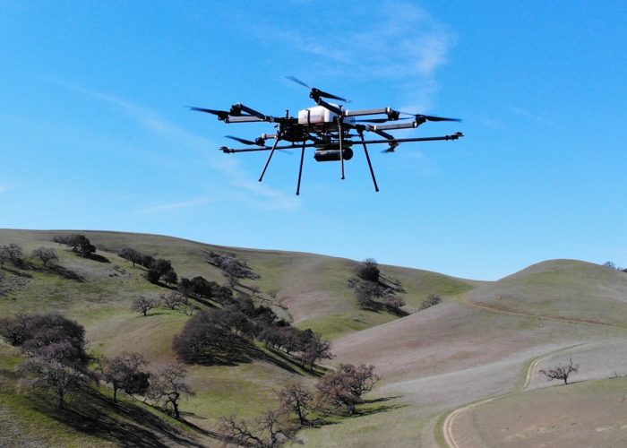
Skyfront’s Perimeter 8 drone achieved a 3 hour flight time with the Routescene UAV LiDAR system as a payload
Line of Sight drone flying is the accepted legal norm. Legislation always lags behind technological advancement and the entrance of longer endurance drones has increased pressure on legislators to approve BVLOS for wider use. Legislation is country-specific and typically BVLOS permissions are issued on an exception basis. These permissions are becoming easier to obtain yet are still a significant challenge to secure. There are specialist test sites around the world working to prove the robustness and safety of longer endurance drones to inform a change in legislation. When new legislation arrives there will be rapid growth in the breadth of UAV LiDAR applications and number of projects being undertaken.
4. Increased adoption of QA/QC
We have witnessed a significant increase in interest for Routescene’s Ground Control Targets over the last 12 months. As the market for UAV LiDAR systems has expanded and matured over the last 2-3 years this has fueled the requirement for more sophisticated outputs and outputs that can be verified. Users are beginning to appreciate that undertaking a UAV survey project is not as simple as taking aerial photographs. Users are partnering with survey practitioners trained in ground control and with QA procedures in place to accelerate their learning and bring step changes to their QA/QC methodology.
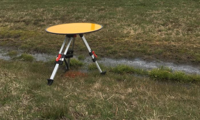
Routescene Ground Control Target
A live study to assess the need for ground control in drone mapping projects is being undertaken by geospatial specialists at the University of Newcastle, UK. If you would like to find out more and participate you can register your interest here.
5. Demand for improved data processing
The challenge when undertaking a LiDAR survey is processing the vast amount of raw LiDAR you collect. The demand for faster data processing, producing cleaner and more accurate results continues. To enable this users need access to improved efficiencies through logical workflow, enhanced and a wider array of point cloud classification functionality, and the ability to generate and share additional “data products” from the point cloud. The post-processing software now on the market offers more functionality than before including data cleaning, contouring and automated classification and we anticipate user demand for such functionality will continue to grow. We forecast that software advancements will enable users with less specialist GIS knowledge and skills to produce high-quality, meaningful results.
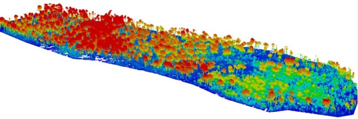
Creating meaningful results through Routescene’s LiDAR data processing software
Summary
We predict an interesting year ahead in the UAV LiDAR systems market, we expect increased demand in conjunction with increased product choice. It will need a discerning buyer to cut through technical specifications to choose the right system for their needs. Lower cost to entry will attract new types of users, which will broaden the types of applications for which the technology is used, which in turn will bring new challenges. Changes to legislation to enable BVLOS will bring further opportunities. All of this will necessitate improved workflow and data processing functionality to enable larger-scale LiDAR projects to take place.