Using UAV LiDAR to understand the characteristics of forest fires
Forest fires are becoming more common due to climate change and bring considerable ecological and economic loss. Understanding the characteristics of a fire – its’ severity and distribution within a forest – will quantify its’ impact. These characteristics will indicate the likely level of post-fire regeneration and ecosystem recovery. This in turn will help develop post-fire forestry management plans. The information can also be used to better estimate and model fires in the future to aid prevention and improve fire containment.
Wildfires don’t burn evenly through forests. What remains of trees and vegetation after a fire is a good indication of its’ severity. In a forested landscape some areas may be barely scorched. However, in other parts the trees will be severely damaged with branches and leaves fully burnt.
In this study the research team assessed the site of the Yeste fire in the province of Albacete, SE Spain. They used high resolution LiDAR data (Light Detection and Ranging) captured from a drone and satellite optical imagery. The team wanted to compare the data acquired using the two different technologies to appraise the potential of UAV LiDAR data for the future.
UAV LiDAR mapping overcomes the limitations of satellite imagery
Satellite optical imagery is being increasingly used to examine the extent of forest fires. However this technique only visualizes the canopy. LiDAR overcomes this constraint. The lasers in a LiDAR system can penetrate through the gaps in the foliage to capture the lower levels of vegetation and the ground below. The resulting 3 dimensional point cloud provides a high resolution visualization of the canopy, the different layers of understory vegetation and the ground. In addition, if the drone mounted LiDAR system is flown at a low altitude and slowly across the survey site this enables an even greater level of detail to be captured. Using a drone LiDAR system individual trees can be detected and the vertical profile of the forest can be viewed.
The study sites
The Yeste fire occurred in July 2017 and in total 3,217 hectares of forest were burnt. Six months later the LiDAR drone mapping survey was undertaken using the Routescene RS4 UAV LiDAR system. This was supplied to the team at Toledo University by Grafinta, Routescene’s distributor in Spain. Four distinct areas were surveyed, each around 5-6 hectares in size, three areas with a different level of fire severity of High, Moderate and Low. The fourth area was a nearby control area that was not burnt.
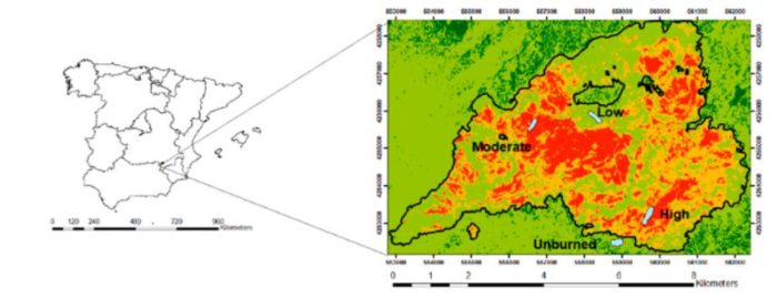
Project location in SE Spain, highlighting the 4 distinct survey areas
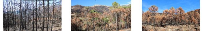
Photographs to illustrate the different fire severity areas surveyed – High, Moderate and Low
Detail of the UAV LiDAR flights
The flights were undertaken at an altitude of 40m above the ground (footprint on the ground was 33 × 204m). Flown in parallel lines 40m apart with an overlap of 50%. The flight speed was between 5 and 7m/s. At this flight height, the spatial distance (spacing) among points was 0.05m. The mean density was 300 points per m². The horizontal accuracy was <2cm and the vertical accuracy <10cm.
Video: Watch the team collecting data using the RS4 UAV LiDAR System and the point cloud results:
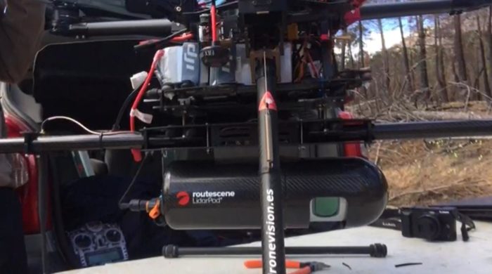
The Routescene RS4 UAV LiDAR System mounted underneath the drone
Analysis of the UAV LiDAR data
Complex analysis of the UAV LiDAR data was undertaken including establishing ground from non-ground points. The team used Routescene’s LidarViewer Pro software to create Digital Terrain Models (DTMs) and Canopy Height Models.
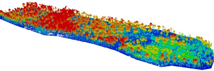
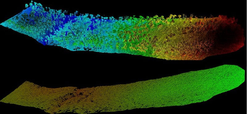
Point cloud of a study area visualized using LidarViewer Pro data processing software
Raw point cloud (above) and non-ground points removed to display the Ground Points (below)
Further analysis enabled the team to classify the data into three clusters. It was found that crown Leaf Area Index (LAI), crown Leaf Area Density (LAD), crown volume, tree height and tree height skewness were the most significant tree structure variables to distinguish the 3 cluster groups.
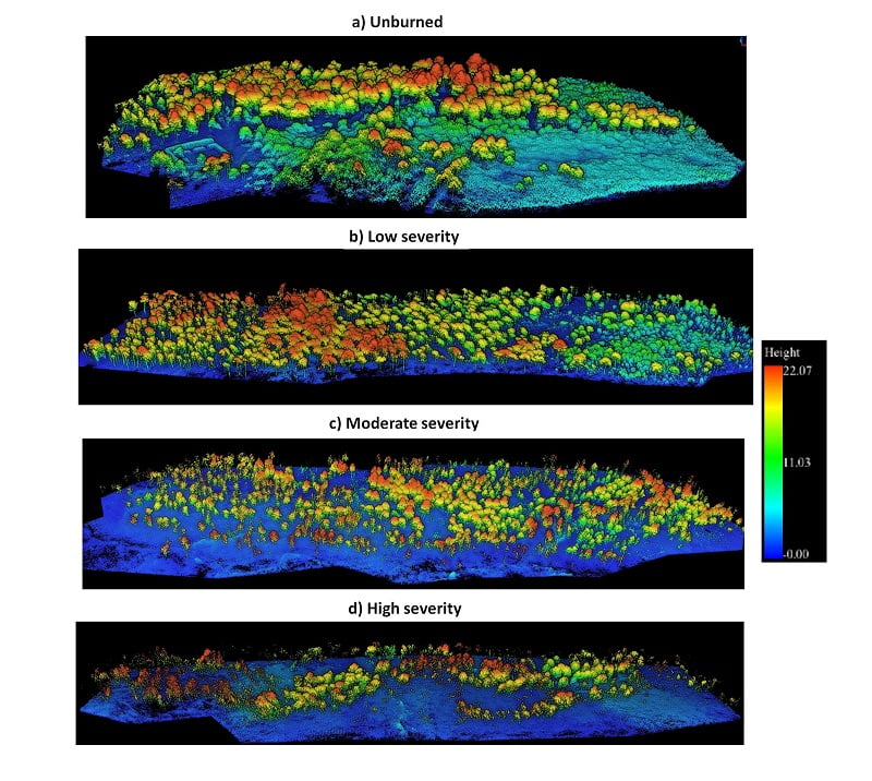
Point clouds of the 4 distinct survey areas
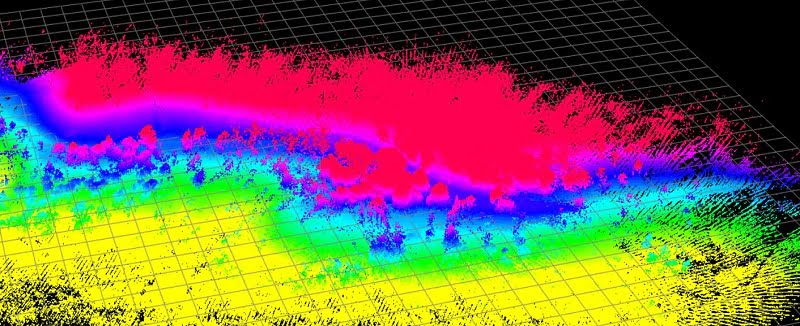
The information was then crossed referenced with fire severity levels derived from satellite images which were acquired a few months before and after the fire.
Drone LiDAR surveying enables a fine-grain assessment of fire severity
Relatively few studies have used drone LiDAR data to characterize crown damage after fires at the individual tree level. Using UAV LiDAR derived metrics the team distinguished crown fire from surface fire through changes in the understory Leaf Area Index and understory and midstory vegetation. They found that unburned and low severity burnt areas were more diverse in tree structures than moderate and high severity burnt ones. This data was previously not attainable using satellite imagery.
The project demonstrated the potential to distinguish post-fire plant structures in detail using UAV LiDAR data. When crossed with satellite-based fire severity metrics, the high resolution results will allow researchers to estimate the impact of fire on single trees not just whole forested areas.
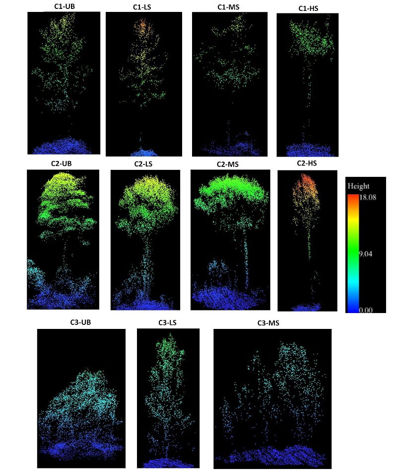
Point clouds of individual trees categorized by fire severity level: UB – Unburned, LS – Low severity, MS – Moderate severity, HS – High severity
UAV LiDAR is a powerful tool to assess damaged forests and refine fire management
“UAV LiDAR, with its level of detail, was the obvious next choice of technology and natural evolution to further examine the levels of damage to individual trees. I am delighted to say the Routescene UAV LiDAR system worked well and proved to be very useful. We have since carried out further studies on forest fires using the system in central Spain and the Canary Islands.”
Olga Viedma, Department of Environmental Sciences, University of Castilla-La Mancha, Spain
In conclusion, the high resolution drone LiDAR data was extremely valuable. It allowed the assessment of forest structure and patterns using metrics which are ecologically meaningful down to an individual tree level. This data can be used to predict fire risk and develop more precise and site-specific fire impact studies. It can also be used to create post-fire management plans.
- Read the more detailed scientific published paper. Postfire Tree Structure from High-Resolution LiDAR and RBR Sentinel 2A Fire Severity Metrics in a Pinus halepensis-Dominated Burned Stand