The Routescene team assisted Innovair, a Scottish based survey and inspection service company, to carry out LiDAR forest mapping of an area managed by Forestry and Land Scotland. This was part of a geotechnical site assessment being undertaken by the engineering consultancy Mott MacDonald.
The aim of this forest mapping was to assist Forestry and Land Scotland, the Scottish Government agency responsible for managing national forests and land, in developing a plan to manage a forest under threat from an approaching plant pathogen. Phytopthora ramorum is a disease which causes rapid mortality in Larch trees.
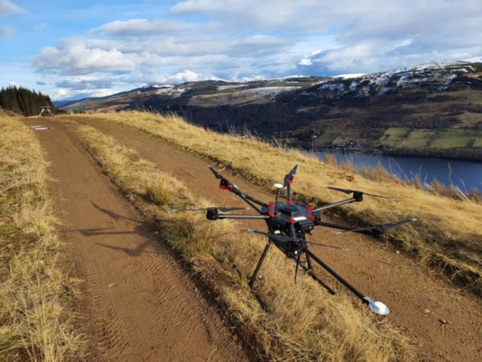
The Routescene LidarPod ready for flight on Drummond Hill, Perthshire, Scotland
Using the Routescene UAV LiDAR and Vehicle LiDAR system, the area of forest around Drummond Hill near Kenmore in Perthshire, Scotland was mapped. The LiDAR system collects impressively dense point clouds which provide a detailed three dimensional view including everything that lies beneath the tree canopy.
Deadly pathogen encroaching on the forest
These maps were used by Forestry and Land Scotland’s East Region team. They assessed the slope stability impacts which constrain and may be affected by the felling of trees due to Phytopthora ramourm. This pathogen is steadily advancing towards Drummond Hill situated next to Loch Tay.

Drone and UAV LiDAR System being prepared to survey the area
Robin Almond, Forestry and Land Scotland’s Planning Forester who looks after this woodland said, “This is a really terrible disease that devastates larch trees for which there is no cure. It is very likely that this pathogen will reach the larch on Drummond Hill within the next decade. The scenic beauty and character of the area could be very seriously affected. Our only solution is to plan felling of the larch before they become infected so as to maintain as far as possible the landscape value of the woodland.”
Robin added, “To limit the impact of this tree felling we need to plan now. The LiDAR system allows us to map the forest and the ground surface below to a high resolution. This data helps us to plan and refine our actions with a high level of detail. We are also able to map potential access routes for a range of machinery that will enable different felling techniques.”
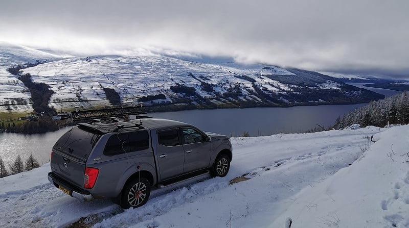
Vehicle LiDAR survey of Drummond Hill using the Routescene LidarPod
Benefits of LiDAR forest mapping
Vegetation penetration is one of the key benefits of the Routescene UAV and Vehicle LiDAR system. High resolution Digital Terrain Models (DTMs) can be created without disturbing the land. The Routescene LidarPod, the 3D mapping tool which is mounted to either the drone or the vehicle, incorporates the Velodyne HDL-32 LiDAR sensor. With a scan rate of up to 1.4 million points per second from 32 lasers angled at a 40 degree field of view, the system is able to penetrate gaps in the canopy to hit the ground and other features in the landscape. Even through vegetation up to 400 points per m2 can readily be achieved. This provides a high level of detail which other survey techniques such as photogrammetry are unable to do.
Robin commented, “LiDAR forest mapping is more effective than a visual walkover inspection when it comes to covering the entire site. It is also better for identifying surface hazards like crags or large, loose boulders. These can be hidden from view and may need to be made safe in case they are dislodged during the felling works.”
Saving time using both Vehicle and UAV mounted LiDAR system
Jamie Watt MRICS, Survey Director at Innovair, mentioned, “For maximum benefit we used the Routescene LidarPod mounted on both a UAV and a vehicle during this project. There are a number of forest tracks on the hill which we were able to drive with the LiDAR system mounted onto the roof rack of a vehicle. This allowed us to scan the paths and surrounding area. Difficult to reach areas were then separately mapped using the LiDAR system mounted on a drone. This has enabled us to collect a great deal of data quickly and efficiently.”
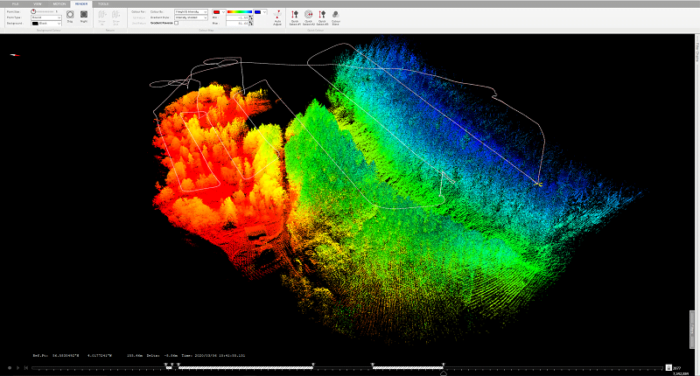
Flight plan of one of the UAV flights
UAV LiDAR output including trees
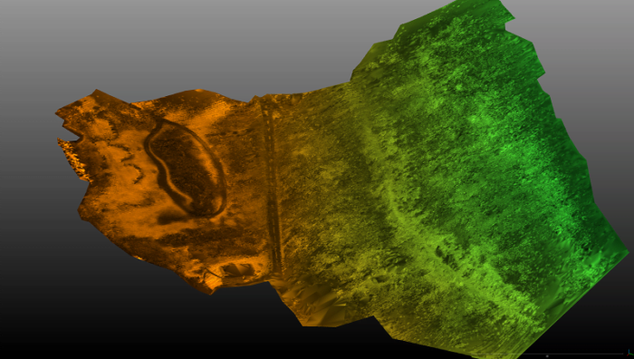
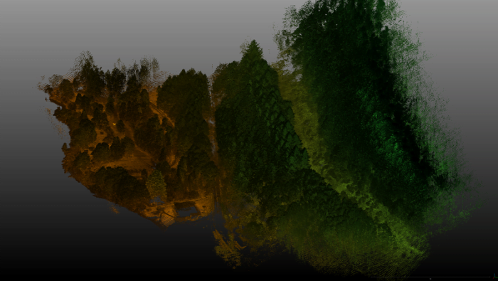
Digital Terrain Model with all points above ground level removed
In addition to developing a felling plan, the team used the data to assess the impact of fewer trees on the hill on peak water flows. They could then design a suitable drainage plan to lessen the risk of flooding. This is particularly useful for the safety of the public road situated below the woodland.
Minimizing exposure to risk
Jamie said; “Using the measurements gathered from our specialist UAV payloads we built an extremely precise DTM model of the forest floor. Working with the geotechnical engineers from Mott MacDonald we are able to pinpoint any issues. Also, we have identified where additional safety measures are required such as catch-fencing. Drones are the perfect vehicle for surveying remote locations. They minimize the number of personnel working on-site and reduce their exposure to risk. The team can plan the work schedule in meticulous detail and carry it out safely and sensitively.”
Jason Rogers, Marketing Manager at Routescene commented, “This is an incredibly valuable forest mapping project which we are delighted to be involved with. My family spends a great deal of time at Kenmore and the surrounding area. We know Drummond Hill very well. It would be such a shame if the pathogen spreads to the hill which is covered in dense woodland. We wish the Forestry and Land Scotland team every success with the project and hope they are able to conserve the beautiful scenery.”
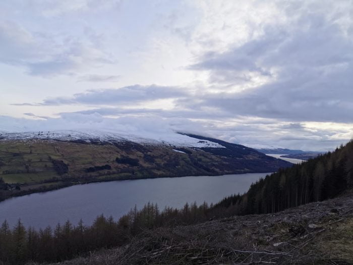
Felling trees to protect the landscape at Drummond Hill, near Kenmore, Perthshire, Scottish Highlands
Once the felling has been completed, Forestry and Land Scotland will plant a mixture of tree species that will retain the character of this important site for many more years.
See more information from the press: