Mapping the Canyons of the Ancients National Monument
When Crow Canyon Archaeology Center and the Canyons of the Ancients National Monument looked to map Sand Canyon, an ancestral Pueblo site in the area, they knew traditional mapping would not suffice. Using UAV (Unmanned Aerial Vehicle) LiDAR technology, they received impressive results and made some new discoveries.
Managed by the Bureau of Land Management, the culturally rich Canyons of the Ancients National Monument in Colorado, USA contain a wealth of historical and environmental resources. Now a recreational hotspot, in A.D. 1240, the Pueblo community occupied the area constructing over 70 villages with approximately 30,000 residents. In Sand Canyon alone over 90 subterranean structures, known as ‘kivas’, were used by families as dwellings. Hundreds of years later, the preservation team were looking for a way to accurately survey this site of archaeological importance. It had been over 20 years since a survey of this caliber had been undertaken and they needed new ways to visualize the area.
In partnership with local UAV service experts, Caddis Aerial, Routescene Inc was chosen to create a high resolution terrain model of the Sand Canyon Pueblo site using their UAV LiDAR 3D mapping solution. This turnkey solution was identified as the perfect system for penetrating the dense vegetation and producing high resolution data.
Watch our video of the UAV LiDAR survey of Sand Canyon and data processing for the project:
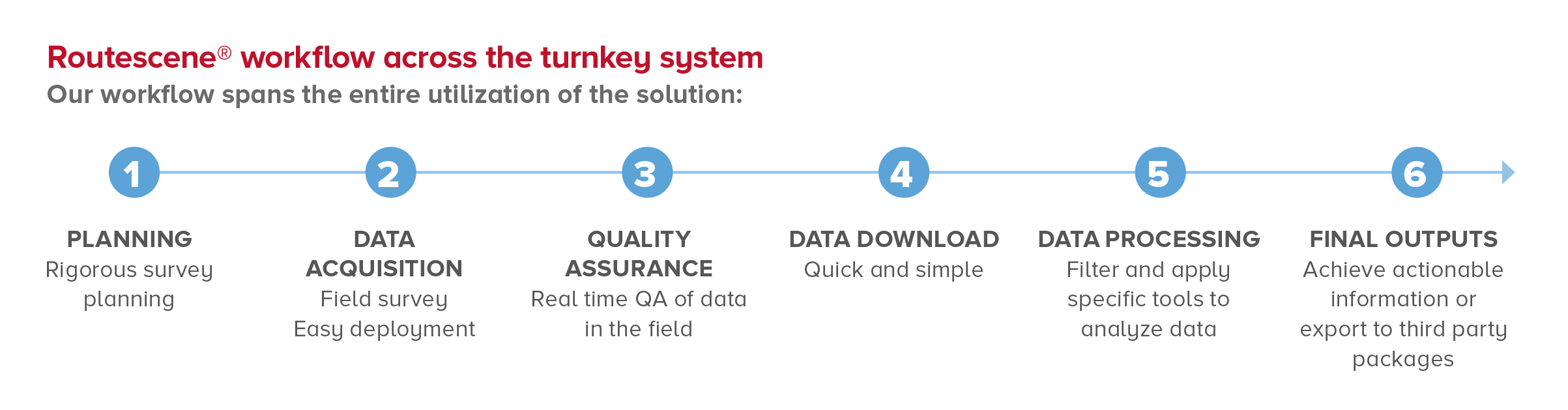
Workflow
Fundamental to the Routescene system is a carefully thought through 6 step workflow which spans the entire utilization of the solution. From survey and project planning, data acquisition, data processing to the final outputs or “actionable information”. This workflow is a set of orchestrated and repeatable procedures and processes. Every survey and subsequent data analysis is undertaken in a systematic, streamlined way; ensuring the best possible outcomes each time.
Surveying the area using UAV based LiDAR
The team started the flight planning process by considering the objectives of the survey and the diverse terrain of the Sand Canyon area. The first objective was to get as high a resolution terrain model as possible devoid of trees and shrubs. The second objective was to ensure a high degree of accuracy. In particular, relative accuracy with respect to the topographic survey conducted many years previously.
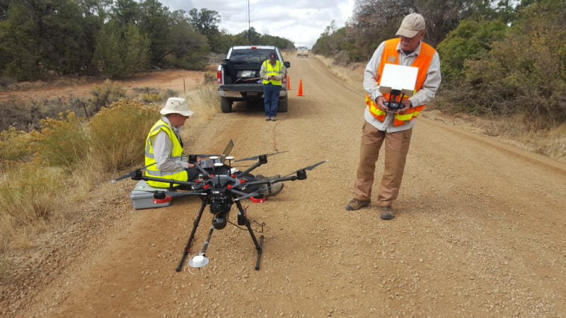
The UAV used was the DJI M600 Pro, chosen for its stability and high lift capacity. This UAV can sustain a flight duration of 15-20 minutes, dependent on environmental factors. In a single flight data can be collected from an area of at least 400 x 400m. Therefore, surveying 2+ km square per day was a realistic and achievable aim. Designed for use on UAV’s, Routescene’s LidarPod is the mapping tool included in their UAV LiDAR solution and it comprises a carefully selected array of sensors. The LiDAR sensor has a scan rate of up to 1.4 million points per second from 32 different lasers angled in a 40 degrees field of view which enables a significantly higher vegetation penetration capability. The LidarPod has a radio modem built in to enable command and control. More importantly it allows operations, complete with real-time QA monitoring, over a distance of more than 2km.
Sufficient line of sight for flying the UAV
The team chose a take-off point on the main dirt road at the north of the survey area. This provided sufficient line of sight to observe the UAV at the outer edges of the survey. The terrain and the direction of slope had to be considered when deciding the direction of flight. The decision was made to fly north-south at 40m altitude relative to the take-off point, which meant that due to the undulating terrain, the altitude at the west and east boundaries was 20m. In the south of the area, the altitude was 60m due to steep cliffs.
The team planned the survey to fly the outer boundaries first, working towards the middle where the take-off point was located. This allowed the team to maximize their flight time so when the UAV batteries reached the lower safety level the time to fly “home” to the landing point was as short as possible.
Setting up the UAV LiDAR System and drone for flight
The aim was to ensure a very high Digital Terrain Model (DTM) resolution. This was achieved by flying as low as safely possible, flying at a speed of 5m/s. Furthermore, setting the overlap between adjacent flight lines at 100% meant each piece of land was surveyed twice. This flight planning not only created a higher data density but also increased the probability of the laser points hitting the ground.
Once the UAV was ready to go, the mission plan was uploaded to the UAV from DJI’s GS Pro app. The M600 Pro was flown manually to the start of the mission and the mission flight plan executed from within the GS Pro App.
Ground control targets – a must for drone based LiDAR surveys
As part of the standard Quality Assurance process, Routescene advocates every survey has ground control established, accurately surveying in Ground Control Points (GCP) and placing Routescene Ground Control Targets on those points. In this survey, the first day was spent establishing ground control and undertaking reconnaissance of the site. The targets were 60 cm in diameter and mounted on small tripods. Covered in a highly retroreflective material, they are easy to identify in the resultant point cloud.
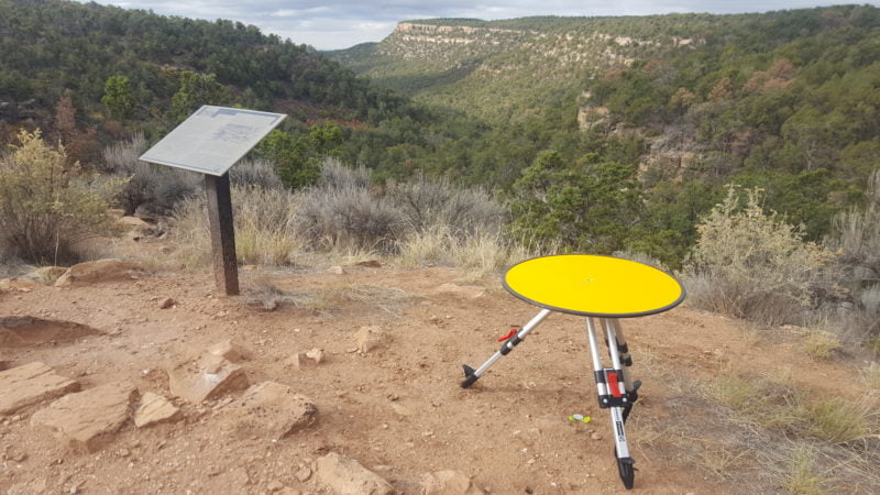
Routescene Ground Control Target specially designed for UAV surveys
Best practice to resolve discrepancies
For any survey there is always a possibility that additional data will need to be collected at a later date, be it unplanned or planned. As standard practice Routescene permanently mark all GCPs using a peg driven into the ground. And in this instance this best practice allowed the team to revisit the site to resolve a problem. During the data analysis a discrepancy was identified in the position of the control points relative to the processed point clouds. The second visit was in the middle of winter and the control points were located under a foot of snow and the points resurveyed. After extensive analysis, it was revealed that the use of Microsoft Excel to store the GCP coordinates was proving detrimental. Excel rounds all numbers to six decimal places and, as it was storing geographical coordinates, this caused the team to lose up to 4m of accuracy. Reloading the original raw data into another format restored our accuracy but left our ground survey team members slightly displeased. A lesson learned.
Processing the data
Efficient data processing is crucial. After every mission, the data was downloaded from the LidarPod and inspected using Routescene’s proprietary LidarViewer Pro software. This software provides a framework on which to build a LiDAR processing workflow and offers filters and a Filter Development Toolkit to develop and apply specific filters to the collected point cloud. The filters and workflow enables the user to achieve the most accurate final deliverables as quickly as possible.
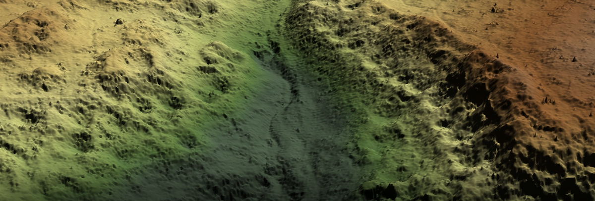
In this project more than 3.2 billion points were collected. It was important that the high resolution of the data was maintained during analysis to create a Digital Terrain Model. The filters used in an automated sequence were sector reduction, laser ID reduction, coordinate conversion, grid creation, the purpose-built “Bare Earth tool”, a skim grid and finally a LAS export filter. This process virtually removes all the vegetation from the site to expose in detail the structures that the archaeologists were interested in. The resolution of the final output was an impressive 400 points/m2.
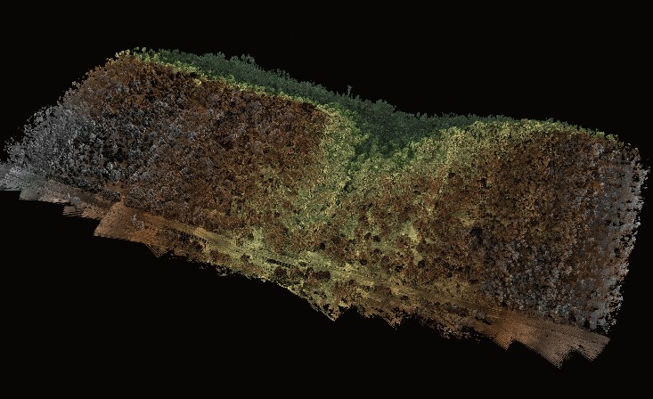
The raw point cloud data visualizing Sand Canyon
Bingo at 40%
The overall survey experience was mostly positive for the team involved. The survey was undertaken in October 2018, at that time of year the temperature was 15-20 degrees C in the early morning, increasing another 5 degrees as the sun came out. The altitude of the survey area was 7,000 ft and this altitude had to be considered in the UAV mission planning as any aircraft’s performance is reduced the higher it flies. In this project, the density altitude was also a significant consideration. Density altitude is the altitude adjusted for atmospheric conditions, such as temperature and humidity. Operating early in the morning when the air was cooler made a significant difference to the density altitude, which was calculated at 9,000-10,000ft.
The UAV flying was a challenge for many factors… not just density altitude but also pilot experience on the craft, a newly purchased aircraft and the payload. The agreement was made to return home when there was 40% battery remaining. This is a generous safety margin but, given all the factors, was deemed to be a sensible approach. When the 40% battery capacity was reached then the current flight line was completed and the UAV brought into land, typically landing at 30% capacity.
The wind tended to increase mid-morning making the flying conditions even more challenging. Four separate flights were completed with no incidents. The team finished the last flight line just before the wind further strengthened to beyond operational flying limits.
Surprising results
The results gained from the survey proved to be accurate and surprising for the preservationists involved. Although the Sand Canyon Pueblo was studied, mapped, and excavated between 1984 and 1995 using traditional survey techniques, the Crow Canyon Archaeological Center were excited to discover previously undocumented structures. The LiDAR image proved to be the best tool for visualizing the ancient site in detail and to plan future preservation. Removing the need for painstaking ground surveys, the impressive data accelerated understanding of the Pueblo area and has allowed the client to concentrate their future work on the newly found structures.
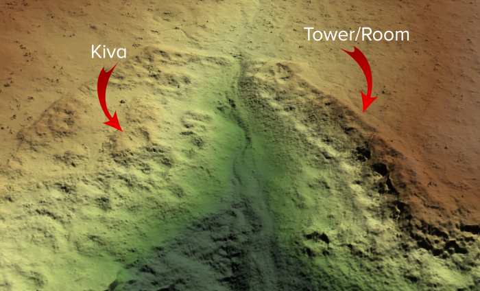
The 750 year old Kivas could be seen in the Bare Earth LiDAR model
Astonishing impact of the survey
The impact of this survey approach is truly astonishing. It illustrated how the tool could be used to record undocumented sites with unprecedented precision. It removed the need for a painstaking ground survey and the speed of delivery of such detailed results is impressive. It has accelerated our understanding – the results indicate the Pueblo was more extensive than we had previously imagined.”
Mark D. Varien, Executive Vice President of the Research Institute at Crow Canyon Archaeological Center