Routescene UAV LiDAR mapping technology used to map Chernobyl forest
After thirty years since the explosion at Chernobyl, a team of researchers have used the Routescene UAV LiDAR mapping system to create a map of radiation levels in the Red Forest next to the nuclear power plant.
The research was led by Professor Tom Scott from the School of Physics at the University of Bristol in the UK. The team consisted of researchers from the National Centre for Nuclear Robotics (NCNR), a consortium of 8 UK based universities. NCNR is developing cutting edge methods to solve the problem of nuclear waste. The project aim was to survey a variety of sites surrounding the power plant including the abandoned village of Buriakivka and the heavily contaminated Red Forest which are close to the damaged reactor.
UAV LiDAR System used to survey selected areas in detail
The team operated a variety of Unmanned Aerial Vehicles (UAVs) and each drone type was used for different survey tasks. Fixed-wing and hexacopter drones were flown over the wider survey area, the team flew for a total of 10 days and covered an area of approximately 6 square miles. When smaller areas of interest were identified the Routescene 3D drone mapping system was flown on a DJI M600 drone to survey in greater detail. Routescene’s LidarViewer Pro software package was used to generate Digital Terrain Models (DTM) which were overlaid with the results of gamma spectrometer surveys.
Watch the video of the Routescene UAV LiDAR System surveying the Red Forest near Chernobyl:
High resolution Digital Terrain Models required
We required high resolution terrain and digital models of buildings for our hotspot identification algorithm. The UAV LiDAR system also helped to show the three-dimensional shape of some of the buildings. The algorithm converts the aerial radiation intensity recorded by a UAV survey into a ground intensity map. Therefore we required a LiDAR based model with a high level of accuracy.”
Dr Kieran Wood, Senior Research Associate at the University of Bristol
The Routescene UAV LiDAR System can capture up to 1.4 million data points every second using 32 lasers. Most importantly, Routescene’s 3D mapping technology allowed the team to take measurements at a safe distance from radioactive areas.
See the video showing the full point cloud and bare earth point cloud used to create a Digital Terrain Model:
Unexpected results
It was already known that the Red Forest still has widespread contamination from radiation. The results revealed an uneven distribution and some areas remain highly contaminated and continue to be a danger to visitors.
One unexpected hotspot was identified. On investigation, it was established that this was the ruins of a facility used to separate waste and it was contaminated during initial clean-up efforts. This area was difficult to identify from satellite imagery but easy to identify in the detailed UAV LiDAR survey results. Small fragments of spent nuclear fuel located at the sorting facility were emitting so much radiation that in a few hours a person would receive a dose of radiation usually absorbed in an entire year.
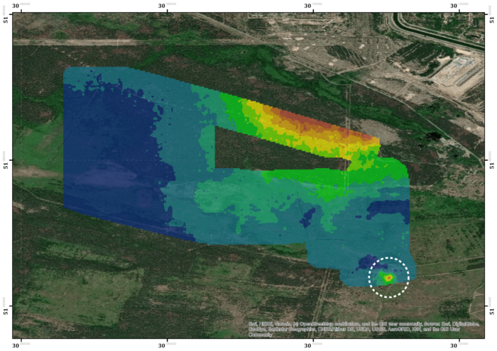
Map of the radiation levels in the area around Chernobyl including the unexpected hotspot. Credit: NCNR/ University of Bristol
In conclusion, the team learnt a great deal from their time in Ukraine. The new detailed maps created of the areas surrounding the Chernobyl nuclear reactor will assist with the safety management of officials and visitors in the future. In addition, if the UK were ever to have a nuclear accident the team have created processes for mapping radiation levels. Further results are due to be published soon.
- See more about this project
- Chernobyl project in GIM International
- See more about the Chernobyl case study in the press