Archaeological UAV LiDAR surveying reveals hidden structural elements
The Routescene UAV LiDAR System and data processing software were key components in an archeological survey on Alderney in the Channel Islands, UK. The project and the UAV LiDAR System features in a TV documentary titled “Adolf Island” broadcast on the Smithsonian channel.
The project was led by Caroline Study Colls, Professor of Conflict Archaeology and Genocide Investigation at Staffordshire University, and the objective was to locate and digitally recreate a German SS concentration camp that was based on the island during World War II. During the German occupation the camp was built but little is known about the estimated 4,000 labourers who were forced to work there, how many died and how many could be buried on the site.
In late 2018 the Staffordshire University team travelled by boat to the island. Joined by Routescene customer FlyThru they conducted aerial surveys using a drone to investigate the camp and potential grave sites. Information was gathered using different survey techniques: UAV LiDAR, UAV photogrammetry and Ground Penetrating Radar (GPR).
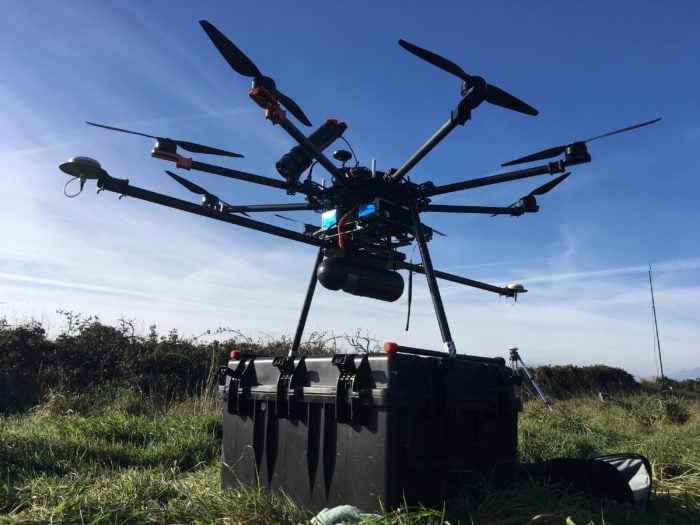
The Routescene LidarPod payload mounted underneath an M600 DJI drone
UAV LiDAR surveying ideal for vegetation penetration
The ability to penetrate through vegetation to the ground beneath is one of the key benefits of UAV LiDAR systems. Data can be collected to create high resolution Digital Terrain Models (DTMs) without disturbing the land or vegetation. Using the payload on a drone removes the risk of damaging or displacing any valuable structures or artefacts hidden out of sight in the undergrowth. Drone LiDAR systems are increasingly being used for archaeological, heritage and forensic investigations because of these advantages.
Completely overgrown with thick vegetation, this capability meant the Routescene UAV LiDAR System was the best tool for this sensitive site.
Background to the survey site
After studying RAF reconnaissance photography taken during the war, along with records from a German War Graves Commission investigation in 1960, the team had a rough idea of the location of the camp. The Sylt site was a notorious labour camp built by the SS and Longis Common was the location of the known grave site. As part of this project the team wanted to use the UAV LiDAR System to identify any new structures of the prison camp and discover if there were any other grave locations.
Uncovering overgrown ground features
The Routescene UAV LiDAR System was developed using a carefully selected array of sensors. With a scan rate of up to 1.4 million points per second using 32 different lasers angled in a 40-degree field of view, the LiDAR sensor was specifically chosen for its’ ability to penetrate through vegetation. The system detects landscape features, surface vegetation and the layers beneath through to the ground using laser pulses.
See the video of the Alderney project and creation of the Bare Earth Model:
The team gathered up to 400 points per square metre on the ground even through thick vegetation cover. This highly detailed data can be processed to uncover ground features which are not visible with the naked eye.
“It would have taken weeks to survey the area with conventional means, and due to the thick undergrowth it would not have been possible to find the structures with the naked eye. We were able to survey the site in just a couple of 15 minute drone flights.”
Michael May, FlyThru, UK
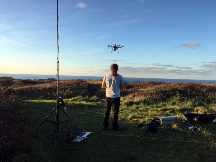
Flying the Routescene UAV LiDAR System over the highly vegetated survey area
Fast data processing
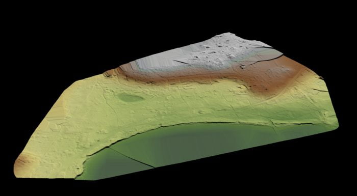
The data was processed that evening using LidarViewer Pro software. Millions of data points were collected and the team applied a number of filters including the ‘Bare Earth Tool’. This tool digitally removes all non-ground points to leave a very accurate bare earth model. The resulting DTM enabled the team to clearly see artefacts and structures across the site.
Watch the Smithsonian channel documentary ‘Adolf Island’:
3D terrain model reveals sites of interest
The data collected from UAV LiDAR, photogrammetry and Ground Penetrating Radar surveys were combined to produce a Digital Terrain Model. The model revealed traces of grave materials in three significant locations. When overlayed with the data gathered by the earlier RAF reconnaissance, Professor Sturdy Colls identified new sites of interest and potentially a mass grave.
Professor Sturdy Colls commented, “The drone surveys conducted by FlyThru using LiDAR and photogrammetry helped us enormously with our research. As the sites were so overgrown, ground based surveys would have been very difficult. UAV surveys were the obvious choice here. The results have proved incredibly interesting. We found structural elements of the camp that were simply hidden in the dense vegetation and we could not see.”
Gert Riemersma, founder and CTO of Routescene added, “We are delighted to see the Routescene UAV LiDAR System and LidarViewer Pro software being used in such important research. Drone based LiDAR surveying is a quick and effective way to map sites covered in dense vegetation. Being able to analyze and interpret the results onsite whilst all the specialists are on-hand at the location obviously accelerates projects incrementally.”
- See where this project has appeared in the press