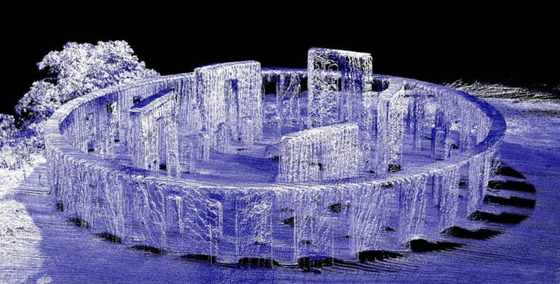
WWI monument captured using drone LiDAR
The Glasgow School of Art has published a book to celebrate some of the most beautiful and striking LiDAR point cloud datasets from around the world.
Routescene® entered the “Art of the Point Cloud” competition with a stunning LiDAR scan of a military monument. Located in Maryhill, Washington State, USA this is the first monument in the USA to commemorate the lives of military personnel lost in World War I.
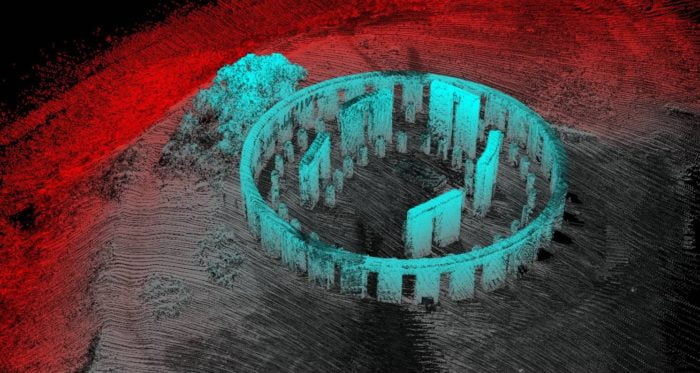
Digitizing the Stonehenge replica
What is unique about this imagery is that it is the first LiDAR scan of the Stonehenge replica, which is an exact copy of the original in the UK. The monument also serves as a lasting reminder of Samuel Hill, the patron of Maryhill, who established a township, experimented with paving roads and set up the Maryhill Museum. When Hill, a Quaker pacifist, visited England during the 1914-18 conflict he saw Stonehenge. He was told it was used for human sacrifices to pagan gods. He remarked that “After all our civilization, the flower of humanity still is being sacrificed to the god of war”. From that inspiration came the monument and it was completed in 1928.
What is also interesting about this story is the convergence of timekeeping and technology from the Neolithic to modern day. Early humans would have known the importance of the sun and its light in their daily lives. From the short, dark, cold winter days when food supplies grew low, to the return of light and warmth which meant crops would grow and animals thrive. It was this yearly cycle and the annual movements of the sun that inspired Neolithic people to construct a precisely aligned monument: Stonehenge. A prehistoric temple aligned with the movements of the sun.
Routescene LiDAR aerial mapping technology – a modern approach
Fast forward to modern day and to the Routescene UAV LiDAR System, the LiDAR mapping technology used to scan this replica Stonehenge. A highly complex 3D mapping tool, it brings together two emerging technologies: LiDAR and Unmanned Aerial Vehicles (UAVs). The site was surveyed in a single 10 minute UAV flight, plotted by Brian Dalrymple using a DJI S1000 octocopter. Strong updrafts and a steady stream of onlookers who stopped to watch the spectacle made for an interesting afternoon.
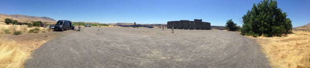
Preparing the drone and UAV LiDAR System at the survey site
This new technology uses modern GNSS positioning, high speed processors and LiDAR which rely on accurate timing to synchronize the UAV GPS trajectory with precise laser ranging. All are essential to produce a highly accurate point cloud. And so we have come full circle – timekeeping is a vital part of the tool which has captured this wonderful LiDAR scan of a prehistoric precise timekeeping temple.
Point cloud of the military monument captured using LiDAR aerial mapping
Considering artistry, the viewer is immediately drawn to the symmetry of the scan and the immense detail down to the texture of the stone. The strong shadows seen in the scan again make a direct connection back to the purpose of the original monument, an ancient timepiece.
With acknowledgment to the Maryhill Museum. Thanks for the permission to fly and for providing all the historical information.